Desertification and Land Degradation Atlas of Selected Districts in India
Project details
Space Application Center - ISRO
2018
Research
CAG
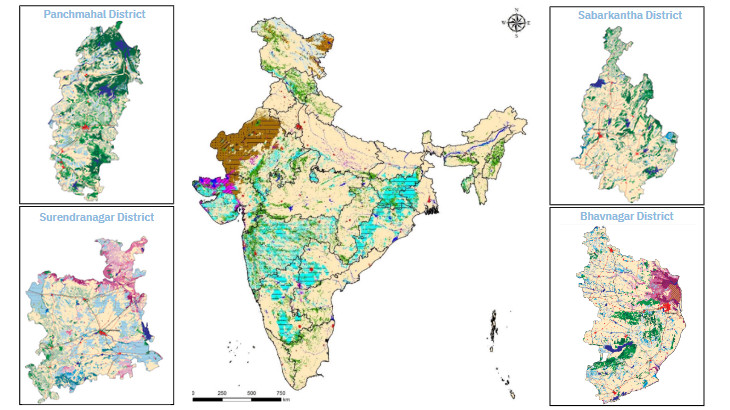
Desertification and land degradation are global challenges with significant economic, social, and environmental implications. As a signatory to the UN Convention on Combating Desertification, India is committed to achieving neutrality in land degradation by 2030. In collaboration with government departments and academic institutes, the Space Applications Centre (SAC) of the Indian Space Research Organisation (ISRO) has completed the "Desertification Status Mapping of India '' project. This project utilised satellite data to produce comprehensive Desertification/Land Degradation Status Maps nationally. These maps identify degraded areas, processes involved, and severity levels, emphasising the need for preventive measures and sustainable land use practices. The project's Atlas, available on the web portals of MoEF&CC and SAC, provides vital information for policymakers, regional planners, and researchers. It highlights the significance of addressing causes like water erosion, wind erosion, and vegetation degradation. Moreover, the project contributes to India's reporting to UNCCD and aids in effectively monitoring and combating desertification and land degradation.
The Center for Applied Geomatics did an analysis of four districts in Gujarat: Surendranagar, Panchmahal, Sabarkantha, and Bhavnagar. Through this geospatial analysis, the center has facilitated the understanding and assessment of various aspects, including land use, environmental changes, and resource management in these districts for desertification and land degradation. The insights gained from this analysis are valuable for informed decision-making by policymakers, local authorities, and stakeholders, promoting sustainable development and effective planning in the respective districts.
More Projects from CAG