Case Study on Open Spatial Data for Disaster Risk Reduction
Project details
Tonkin And Taylor
2022-2023
Research
CAG
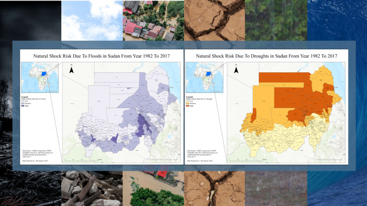
The rapidly increasing frequency of disasters has become a menace to human habitation across the globe. Effective disaster risk reduction and management can be achieved through the deployment of geospatial data for all the phases of disaster management, including prevention, mitigation, preparedness, vulnerability reduction, response, and relief.
As features impacted by disasters are geographically located and have geographic addresses, spatial data plays a vital role in disaster management. It constitutes the disaster management information cell for all phases of disaster management through preparedness, damage assessment, and relief planning. Geospatial data provide information about the areas that are susceptible to flood and locations that people and livestock can be evacuated to in case of a disaster. This project is carried out with the collaboration of Tonkin & Taylor (New Zealand), providing GIS assistants as knowledge-sharing partners.
The project also aims to create the metadata of disaster under the umbrella of FAIR data policy which meets the principles of findability, accessibility, interoperability, and reusability. Data sharing benefits scientific advancement and during a disaster, spatial data sharing helps in taking emergency actions. It encourages collaboration, accelerates research, and leads to better decision-making.
More Projects from CAG